
Tendring Colchester Borders Garden Community Development Plan Document (DPD)
Chapter 3: Land Uses and Spatial Approach
This chapter sets out what land will be included in the Garden Community, how the development will be laid out, which areas will be allocated to housing, employment, open space or other uses or infrastructure, and which areas will be protected from development.
The approach has been informed by a thorough strategic masterplanning process, which has been supported by an appropriate evidence base with proportionate technical evidence, survey work and the comments of local people, stakeholders, and other interested parties as part of public engagement and formal consultation activities.
As well as explaining, in broad strategic terms, how different parts of the Garden Community are expected to be developed and protected, GC Policy 1 also sets out how this Plan will be followed by additional future masterplanning and design guidance, for both the whole of the Garden Community area and the neighbourhoods within it, and how these will be adhered to when considering detailed proposals and specific planning applications.
GC Policy 1 is supported by a 'Policies Map' which can be found at the end of the policy and at Appendix 2. Appendix 3 includes illustrative masterplan maps taken from the Strategic Masterplan
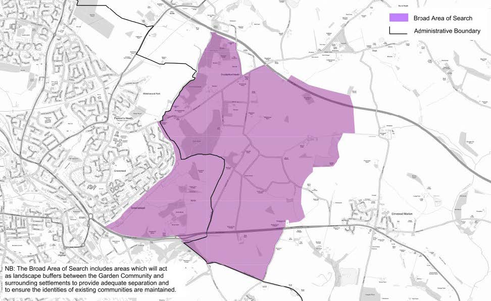
Broad Area of Search
The map below is the 'Area of Search' for the Garden Community, as specified in the Section 1 Local Plan. This map is not the Policies Map however it shows the broad area of land identified by the Councils where it is envisaged most of the Garden Community will be located.
FIG.1 BROAD AREA OF SEARCH
STRATEGIC ILLUSTRATIVE FRAMEWORK MASTERPLAN
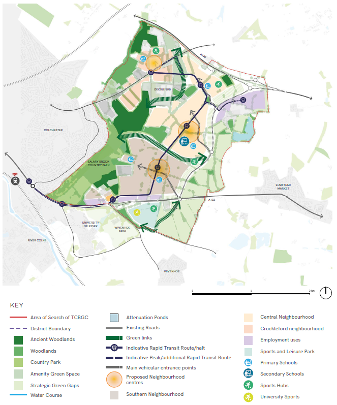
*The location of specific land uses, facilities and activities are illustrative and subject to further masterplanning.
(57) GC POLICY 1: LAND USES AND SPATIAL APPROACH
Taking forward the requirements of the Section 1 Local Plan and taking into account the views of local people and other stakeholders, GC Policy 1 sets out the key land uses and spatial parameters within which the Garden Community is expected to be built. It also sets out the Councils' expectations for the information that will need to be submitted and approved ahead of the determination of any outline or detailed planning applications for development of the Garden Community. This will enable the Councils to ensure that development will achieve a comprehensive approach that delivers garden community principles and the Councils' high expectations for design and quality as set out in this Plan.
Proposals will be designed to ensure that the new Garden Community will develop as an inclusive, safe, and healthy community. They will represent sustainable developments that manage natural and heritage assets wisely for future generations and existing communities. The new Garden Community will make the fullest possible contribution to minimising greenhouse gas emissions by ensuring resource efficiency, minimisation of waste, reduction in embodied carbon, the prioritisation of renewable energy and through maximizing sustainable and active modes of travel. Proposals will mitigate against and improve resilience to the effects of climate change and contribute positively to the health, wellbeing and resilience of communities and the natural environment.
Part A: Land Use Parameters and Policies Map
Development will be confined to land within the Garden Community location as identified in the Section 1 Local Plan and will adhere to the 'Land Use Parameters', as shown on the 'Policies Map'. Land within the identified Garden Community location is specifically allocated or protected for the following uses:
- Delivery of circa 7,500 new homes with a range of shops, jobs, services and community facilities, including education (see Part B below).
- A new 'Salary Brook Country Park' incorporating land and woodland at and around the Salary Brook Local Nature Reserve (see Part C below).
- A 'Wivenhoe Strategic Green Gap' incorporating land north of Brightlingsea Road and west of Elmstead Road (see Part D below).
- An 'Elmstead Strategic Green Gap' east of the new A120-A133 Link Road (see Part E below).
- A Sports and Leisure Park to serve the local community and for the expansion of sports facilities for the University of Essex (see Part F below).
- Approximately 25 hectares of employment land in form of a new Business Park and a 'Knowledge-Based Employment' site (see Parts G and H below).
- Provision for the Rapid Transit System.
- A Gypsy and Traveller Site (see Part I below).
- A 'Park and Choose' facility (see Part J below).
Proposals for development must comply with the 'Policies Map' and meet the specific requirements of policies elsewhere in this Plan and in the adopted Section 1 Local Plan.
Any proposal for land within or nearby the Garden Community location that would prejudice the comprehensive development of the Garden Community, as envisaged by the 'Policies Map', the Councils 'Strategic Masterplan', the policies in this Plan or any subsequently approved Masterplans and Design Codes, will not be supported by the Councils.
Part B: The Garden Community Neighbourhoods
The Garden Community Neighbourhoods, extending from the A133 to the A120, will be the principal focus of new development and will deliver three distinct, but interconnected 'Neighbourhoods' containing circa 7,500 new homes of varying size, type, tenure and densities.
'South and North Neighbourhoods'
Broad locations for two distinct but interlinked Neighbourhoods, referred to as the 'South and North Neighbourhoods' are shown on the Policies Map. The 'North and South Neighbourhoods' between them will accommodate around 6,000-6,500 new homes. Development within and across the two 'Neighbourhoods' will be phased to ensure housing development is aligned with infrastructure delivery, with an expectation that the early phases of development will begin in the 'South Neighbourhood'.
Each 'Neighbourhood' will adopt appropriate approaches to architecture, design, character, density and public open space to achieve a distinctive sense of place that will appeal to a variety of needs and lifestyles. The approaches to development will also reflect the varying levels of physical and environmental opportunities and constraints across the site, as well as proximity to existing communities, key features and assets – such as green spaces, woodland, heritage assets, the University of Essex, new and existing roads, lanes and walking and cycling connections.
Residents within the 'South and North Neighbourhoods' will have high accessibility to local services and facilities. To facilitate the use of walking, cycling and public transport as the preferred alternatives to the private car, each neighbourhood will develop around a 'Neighbourhood Centre' containing shops, services, and community facilities, and where appropriate employment land and job opportunities. The centres will be connected to the neighbourhoods by coherent, direct, safe, and attractive walking and cycling routes designed around the 20-minute neighbourhood principles. Land and property will be provided in the form of 'hubs' within, around and along a corridor of activity between both 'Neighbourhood Centres' to provide for a flexible range of local business needs alongside service sector jobs provided by new schools, nurseries, shops and community facilities.
The provision of student accommodation will be encouraged in accessible locations within the 'South Neighbourhood' where it would have good sustainable links to the University of Essex and where it will contribute to a mixed and diverse community.
The new Rapid Transit System will connect the 'South and North Neighbourhoods' as part of a wider network, providing fast and reliable connectivity between them and key areas of employment both within the site and in surrounding areas, such as the University of Essex, the City of Colchester, Colchester General Hospital, and Colchester Sports Park.
The 'South and North Neighbourhoods' will each be accessed independently from separate vehicular junctions on the new A120-A133 Link Road (as opposed to the A133 and A120 themselves) in order to give priority to the Rapid Transit System and active travel modes. The Councils will work with the University of Essex and other partners, as appropriate, to deliver the key infrastructure (health, education, and other community uses) necessary to serve the early phases of development. Such infrastructure will be delivered either on a permanent basis, or on an interim basis if it is required ahead of the establishment of the first of the 'Neighbourhood Centres'.
'Crockleford Neighbourhood'
The 'Crockleford Neighbourhood' will be developed as an individual community that is physically separated from, but connected by walking, cycling and other sustainable transport modes to the 'South and North Neighbourhoods' and the City of Colchester. The 'Crockleford Neighbourhood' will grow to accommodate around 1,000-1,500 new homes, with its phasing linked to the provision of its own proportionate 'Neighbourhood Centre', associated infrastructure, and sustainable connections to the 'South and North Neighbourhoods'. Accessibility to services and facilities, utilities infrastructure and the Rapid Transit System will be key to determining the phasing of development in the 'Crockleford Neighbourhood'.
The 'Crockleford Neighbourhood' will develop its own character in an incremental and sequenced manner over the longer-term in line with its own specific Masterplan and Design Code. This will protect and respect the character formed by its heritage assets and their settings, its distinctive network of green lanes, small fields and land parcels. The 'Crockleford Heath Area of Special Character' is shown on the 'Polices Map and reflects the core concentration of buildings, spaces and other features requiring specific consideration as part of any wider proposals for development. Within the 'Crockleford Heath Area of Special Character' development must preserve or enhance the intrinsic character of the area, whilst within the wider setting/environs of Crockleford Heath, development should respect/respond positively to the existing landscape structure.
The approach to residential development will need to involve the sequenced servicing and release of individual parcels of land which could include plots for self-build and custom-built homes, with a mechanism to be agreed for the Councils to secure financial contributions from each home towards the delivery of infrastructure and affordable housing.
Part C: Salary Brook Country Park
Land and woodland around and including the Salary Brook Local Nature Reserve is designated as a new Country Park that will be promoted and managed for that purpose. The 'Salary Brook Country Park' will be protected and enhanced as an important corridor for wildlife conservation, informal recreation, and education, and will connect to the wider network of green and blue infrastructure and walking/cycling routes serving the Garden Community and its 'Neighbourhoods'. This designation will provide protection to this area of countryside and will maintain the long-term physical and visual separation to the adjacent City of Colchester.
The section of the new 'Salary Brook Country Park' between the A133 and Bromley Road shown on the 'Policies Map' will be brought forward alongside the earliest phases of development within the Garden Community with further northward extension being secured longer- term alongside development of the 'Crockleford Neighbourhood'.
Part D: Wivenhoe Strategic Green Gap
Land north of Brightlingsea Road and west of Elmstead Road, connecting Wivenhoe Park and the University of Essex, is designated as a Strategic Green Gap. This designation will provide protection to the open countryside to the south of the Garden Community; maintain the long-term physical and visual separation to Wivenhoe and continue the coalescent break established within the Wivenhoe Neighbourhood Plan. The 'Wivenhoe Strategic Green Gap' will comprise of a strong landscaped edge, protecting the character of the surrounding landscape and creating new enhanced habitats for a range of biodiversity. It will connect to the wider network of multifunctional green and blue infrastructure and walking/cycling routes serving the Garden Community and its 'Neighbourhoods'.
Development will only be supported where its role and function would not be materially harmed; it represents the provision of appropriate development for a countryside location; or is for facilities (in connection with the existing use of land or a change of use) for outdoor sport or recreation, renewable energy, cemeteries and burial grounds or allotments.
Part E: Elmstead Strategic Green Gap
Land east of the new A120-A133 Link Road and the new 'Business Park' south of the A120, is designated as a Strategic Green Gap. This designation will provide protection to the open countryside to the east of the Garden Community; maintain the long-term physical and visual separation to Elmstead Market, and to assist in protecting the setting of the heritage assets of the Church of St. Anne and St. Lawrence, Elmstead Hall, Allens Farmhouse and the Round Burrow.
Development will only be supported where its role and function would not be materially harmed; it represents the provision of appropriate development for a countryside location; or is for facilities (in connection with the existing use of land or a change of use) for outdoor sport or recreation, local low carbon energy generation, cemeteries and burial grounds or allotments.
Part F: Sports and Leisure Park and University of Essex Expansion
Approximately 25 hectares of land south of the A133 and north of the proposed 'Wivenhoe Strategic Green Gap', is allocated on the 'Policies Map' for new a 'Sports and Leisure Park'. This will facilitate the enhancement of sports facilities required by the University of Essex as part of its plans for long-term expansion and will provide sports and leisure facilities which will be available for use by residents and clubs in the existing community, the proposed Garden Community and the University.
The 'Sports and Leisure Park' will comprise of a strong landscaped edge to the south, adjacent to the 'Wivenhoe Strategic Green Gap', protecting the character of the surrounding landscape and to creating new habitats for a range of biodiversity. It will connect to the wider network of multifunctional green and blue infrastructure and will provide walking/cycling routes serving the Garden Community and its 'Neighbourhoods'.
Part G: Knowledge-Based Employment Land
Approximately 8 hectares of land north of the A133, opposite Wivenhoe Park and the University of Essex, is allocated on the 'Policies Map' for knowledge-based employment purposes to maximise the benefits arising from close proximity to the University of Essex and the developing Knowledge Gateway. This would be attractive to securing business investment whilst encouraging the provision of sustainable travel trips via walking and cycling routes either directly across the A133, or via the 'Salary Brook Country Park'. Development will be designed and landscaped to make an efficient use of the land available and to ensure an appropriate transition between built development and the open countryside – particularly towards the 'Salary Brook Country Park'.
Part H: A120 Business Park
Approximately 17 hectares of land immediately south of the A120 and east of the new A120-A133 Link Road, is allocated on the 'Policies Map' for a new 'Business Park'. This would be principally used for general employment, business and industrial purposes providing a range of unit types and sizes for different occupiers. The business park will be accessed via the new A120-A133 Link Road and will be connected to the Rapid Transit System.
The 'Business Park' will be designed and landscaped in a manner that ensures an appropriate transition between built development and the open countryside forming part of the 'Elmstead Strategic Green Gap'. Development will be required to respect the setting of the heritage assets of the Church of St. Anne and St. Lawrence, Elmstead Hall and Allens Farmhouse.
Part I: Provision for Gypsies and Travellers
A new site for the accommodation of Gypsies and Travellers will be delivered within the 'North Neighbourhood' to the south of the A120 and west of the new A120-A133 Link Road. A broad location is identified on the 'Policies Map'. The site will accommodate 18 pitches which will count equally (nine pitches respectively) towards Tendring and Colchester Councils' projected need for such accommodation and will form an integral part of the wider Garden Community. The location and size of the site will be informed by the 'Strategic Masterplan' and subsequent Masterplans prepared by the developer, and shall be detailed as part of a relevant planning application.
The Gypsy and Traveller site will come forward in response to need.
Part J: A133 Park and Choose Facility
One new 'Park and Choose Facility' will be developed on land adjacent to the A133 in one of the two the broad locations shown on the 'Policies Map'. This facility will provide the opportunity for visitors by car to access the walking, cycling and Rapid Transit System networks that connect to the Garden Community, the City of Colchester, and the wider area. It will be located where the Rapid Transport System route intersects with the A133 and within close proximity to the new 'Knowledge-Based Employment Land'. The location and size of the facility will be informed by the 'Strategic Masterplan' and subsequent Masterplans prepared by the developer, and shall be detailed as part of a relevant planning application.
The 'Park and Choose Facility' will be delivered and brought forward alongside early phases of development to coincide with the first operation of the Rapid Transport System. It will have the ability to be expanded over time in response to future demand.
Part K: Planning Application Requirements
A comprehensive approach to development must be developed that meets with the Councils' high expectations for design and quality, and the key principles that underpin the development of Garden Communities.
A comprehensive site wide Garden Community Masterplan, detailed Area Specific Masterplans and Design Codes for relevant phases of development should be prepared by the developers through a collaborative process with the Councils and key stakeholders and which should have regard to the Councils 'Strategic Masterplan'.
These will be informed by use of design review and assessment frameworks such as the National Design Guide, National Model Design Code, Building for a Healthy Life and Building with Nature, or similar. These should be approved alongside and/or prior to the determination of relevant planning applications, as appropriate.
Planning applications will be determined considering the policies and proposals within this Plan. For planning applications to be considered valid, a range of information must be submitted including plans and/or supporting documents. The Councils local validation lists are available on their websites and clarifies what information is required. This will vary for different types and scales of application being made and will be reviewed as necessary to take account of statutory changes or Government guidance.
Each individual policy of this Plan specifies required supporting documents that must be submitted either prior to or in support of planning applications. A full list of these documents can be found at Appendix 4.
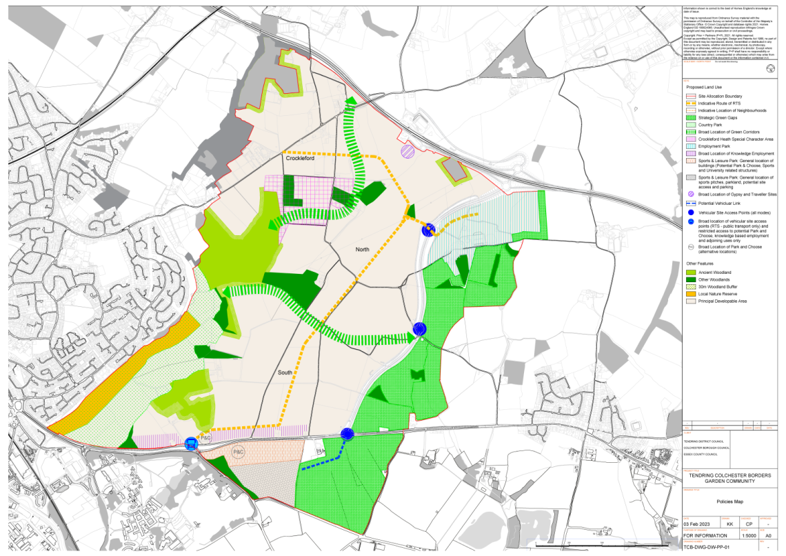
(7) FIG. 2 POLICIES MAP
Justification
The chosen strategy for development at the Garden Community confines the majority of development to land south of the A120, north of the A133, west of the new A120-A133 Link Road and east of a new country park (Part C) to be designated around Salary Brook Local Nature Reserve. IIn addition, selected land around the area of Crockleford Heath has been specifically identified as an Area of Special Character, where development must preserve or enhance its intrinsic character.
Land is designated and shown on the 'Policies Map' as Strategic Green Gaps. Land within the Strategic Green Gaps will be protected from most forms of built development to ensure the Garden Community does not extend or sprawl into locations where it could eventually merge or coalesce with Wivenhoe or Elmstead Market – one of the main concerns raised by local people throughout the public engagement activities. Additional open space is proposed adjacent to Salary Brook Local Nature Reserve to strengthen this area as a buffer to the Colchester urban area encompassing the steep adjoining slopes of the brook as well as nearby woodland. This designation will also prevent coalescence in the Greenstead and Longridge areas.
The evidence has developed to show that the residential capacity of the site is towards the lower end of the 7,000 to 9,000 range set out in the Section 1 Local Plan. This is given the physical constraints of the site with boundaries defined by the Strategic Green Gaps and both the existing and proposed roads. The total number of new homes expected at the Garden Community has therefore been refined to circa 7,500.
The new homes will be delivered across three distinct but interconnected 'Neighbourhoods' (Part B) in the south, north and Crockleford parts of the site, each with associated facilities and infrastructure. Broad locations for these neighbourhoods are shown on the Policies Map. Each neighbourhood will adopt its own approach to architecture, design, character, development density and public space to achieve a distinctive 'sense of place' for each area, that will appeal to a variety of needs and lifestyles. The number of homes and density of housing development will vary both within and across the neighbourhoods, with a general expectation that the overall average density of development will be higher in the southern neighbourhood to reflect its proximity to the University of Essex, and the opportunity for early connection to the Rapid Transit System; and lower in the northern neighbourhoods, further from the University, and which reflects the more sensitive nature of the landscape and existing communities further north particularly around Crockleford Heath.
Each neighbourhood will be served by at least one 'Neighbourhood Centre' and will be focused around high accessibility to the Rapid Transit System. Each neighbourhood will contain a range of employment land and job opportunities, shops, services, and community facilities, including green- blue infrastructure, which will be located within close walking and cycling distance of the new homes, designed to help reduce people's reliance on private cars.

The Garden Community will be planned and developed on the concept of a "20-minute neighbourhood", and this Plan involves a range of interrelated policy actions that seeks to provide residents access to most of their daily needs within a short walk or cycle ride from their home. To help achieve this, higher density development will be focused around each centre. The 20-minute neighbourhood principle makes life more livable for residents, by improving air quality and making neighbourhoods safer, quieter, more diverse, inclusive, and economically vibrant.
Another way of minimising the reliance on private car use is to promote and prioritise sustainable travel choices such as walking, cycling and use of public transport, including the new Rapid Transit System, by making them as convenient as possible, whilst still accommodating the practical needs of private car users and users of commercial vehicles. To help achieve this, as well as providing services and facilities within walking and cycling distance of new homes, connectivity through and between the three neighbourhoods will be primarily limited to walking, cycling and public transport, including the Rapid Transit System. The neighbourhoods will be accessible by private car and commercial vehicles with appropriate levels of parking and electric charging facilities provided, however, access will be from separate junctions on the new A120-A133 Link Road with no direct vehicle access between the neighbourhoods, with the exception of emergency vehicles and public transport. This approach will help to promote and prioritise sustainable transport choices and reduce the possibility of 'rat-running' through the Garden Community.
A new 'Park and Choose' facility (Part J) would be provided for the Garden Community to enable visitors by car to access more sustainable transport choices such as walking, cycling and the Rapid Transit System, which can also provide access to key areas of employment and services within Colchester. This will be located at a location adjacent to the A133 where the Rapid Transport System route intersects with important transport corridors and the two principal areas of employment uses.
The approach taken to delivering employment and knowledge based employment at the Garden Community is designed to deliver a range of job and training opportunities across different sectors, which could include general business and light industrial activity, to research and development, construction, and services. Two principal areas of employment land have been allocated. One will be located immediately south of the A120 and east of the new A120-A133 Link Road (Part H) primarily to serve the needs of general business and industry (which could include manufacturing of green technologies and modular components to assist in construction of the new homes and buildings at the Garden Community). The second would be located on land north of the A133 adjacent to the University of Essex and Knowledge Gateway (Part G). Suitable early years and childcare facilities, and primary and secondary schools will also be provided.
The Councils support the University of Essex in its future plans to expand services, increase student intake and provide business, research and development space and sports facilities, and will support appropriate proposals that will help to achieve this both within and beyond the plan period. The development of a new 'Sports and Leisure Park' will enable the wider expansion of the University of Essex to the benefit of the local economy. The Councils and Developers will work with the University of Essex to make maximum use of land and property on the existing campus for the expansion of its academic facilities and to increase the supply of student accommodation both within the Garden Community 'Neighbourhoods' and elsewhere throughout the City of Colchester where there are good connections to the Rapid Transit System.

Land and property will be provided in the form of 'hubs' within and around the 'Neighbourhood Centres' to provide for a flexible range of local business needs alongside service sector jobs provided by new schools, shops and community facilities. New homes and business premises will also be designed and served by the necessary digital infrastructure to accommodate and promote home working and self-employment.
At this early stage of planning for the Garden Community, it is not possible, nor sensible, for this Plan to contain full or precise details of design, layout and appearance of the new buildings and spaces that will be delivered. Instead, this Plan provides the overarching strategy and policies that will provide direction for more detailed Masterplans, Design Codes and, ultimately, planning applications to follow.